Rowan Castle - Travel & Photography


© Rowan Castle 2019


Iceland 2002 - Diary


Introduction.
I had been feeling that I needed to take some leave from work, but do
something exciting with it. The idea that came to me was to do a short trek,
somewhere in Europe, that ideally would not cost too much. Leafing through an
old copy of Adventure Travel magazine, I re-discovered an article about the
Landmanalaugar to Skogar trek in Iceland. This route is rated as Iceland's
premier walk, and some guidebooks even claim that it is one of the best treks in
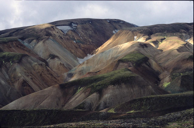
the World! It starts in the South Central Highlands, amongst the colourful
rhyolitic mountains and geothermal vents of Landmanalaugar. These mountains
were laid down by volcanic action, and then dramatically eroded to create
undulating hills of multi-coloured mineral deposits. As the path loses altitude, it
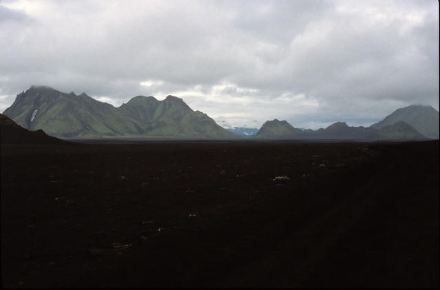
descends out of these hills and crosses a bleak lava desert of black ash,
punctuated by pyramidal mountains and raging glacial rivers. At the other side is
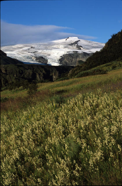
the wide valley of Thorsmork (Woods of Thor), which has stunning views of two
of Icelands huge ice caps - Eyafjallajokul and Myrdalsjokul. The route then
climbs out of the valley, along a sharp ridge and crosses the Fimmvorthuhals
Pass between the two ice caps. From there, it descends sharply to the North
Atlantic coast, finishing at the sixty metre high Skogafoss waterfall at the small
settlement of Skogar.
Along the path are small huts with camping grounds, which can be used for a
fee. The huts get booked up well in advance, so I realized that to do the trek, I
would need to camp and be totally self-supported. This would be a big
challenge, because there was the possibility of extreme weather even during
Iceland’s short summer. I would have to take far more clothing with me than on
a similar trek in the UK or Himalayas. This, along with all of the food and fuel I
would need to carry, meant that my backpack would weigh in at a whopping
55lb. I was feeling a bit more optimistic when I persuaded my Dad to come with
me, but with just three days to go until our flight left Heathrow, he came down
with a severe chest infection and was advised not to trek by his doctor. I was
extremely disappointed when I heard the news, because I knew he would really
have enjoyed the walk. There was no other option - I would just have to go it
alone.
The prospect of trekking the route solo did not worry me unduly. I had excellent
equipment, good maps and a GPS receiver, so it was unlikely that I would lose
the way. In addition, Dick Phillips (the travel agent and renowned Iceland travel
pioneer who had booked my flights and Reykjavik accommodation) informed me
that the route is marked by posts every 100m or so. My only real concerns were
finding enough time to purchase fuel for the trek on arrival, and having to wade
across some of the glacial rivers along the route with no one else around. Above
all though, I was just looking forward to the solitude of trekking through a
remote area and the satisfaction of being self-sufficient.
When the day of departure came round, and I walked from Heathrow’s Central
Bus Station to the terminal building, I was nearly bent double under the weight
and size of my backpack. After I had checked in and no longer had to struggle
with the pack I began to relax. Once on board the plane I was eagerly awaiting
traveling further north than I ever had before.
Day One – 8th August 2002.
The Icelandair flight had not left Heathrow until 00:30, so I was very late
arriving in Reykjavik. As the airport bus drove me from the airport at Keflavik to
the city, I got my first views of Iceland. The landscape was like nothing I had
seen before – a bleak, rocky and treeless expanse stretched out all around. It
looked windswept, cold and uninviting – but then what did I expect? It was a
surprisingly long distance to the city, but when we arrived I was taken aback by
just how big it was. As far as the eye could see there were the twinkling lights
of the neat white houses with corrugated iron roofs. The road ran along the
coast for some way, and the city lights were reflected on the mirror calm
surface of the Atlantic.
The bus terminated at the Hotel Loftleithir, and I transferred to a minibus taxi
that would take me to my accommodation at the Guesthouse Snorri. The bus to
Landmannalaugar left first thing in the morning, and with the late flight, that
left me no time at all to buy kerosene for the trek. It was vital that I find an all
night garage where I could buy some fuel. Luckily, I had been keeping a look out
on the way from the airport, and had spotted one just up the road from the
Hotel Loftleithir. I managed to persuade the minibus driver to take a short
detour and stop there. This was where I had my first bit of good luck of the trip.
Like many Icelanders the staff at the garage spoke excellent English, but had
bad news. The kerosene was locked in a store and would not be opened until 8
a.m. I explained that I would be on a bus to the start of the trek by then, and so
they went out of their way to help me, by opening up the store especially and
finding a litre bottle of kerosene. Now, I had everything I needed to complete
the walk independently.
By the time I got to the guesthouse, booked a taxi for the next morning, poured
the kerosene into my fuel bottle and unpacked my things, I worked out I had
exactly forty minutes sleeping time! Even then, I didn’t get much sleep because
something was making a terrible noise in the street outside – I think it was a cat
wailing. Before I knew it, it was time to get up and get myself ready for the taxi
to the bus terminus.
As the taxi driver drove me through the deserted streets I told him about the
trek I was going to do. When we arrived at the bus station and he lifted my pack
out of the boot, he said he thought I was a tough guy. I said I didn’t know if I
was tough or foolish.
It turned out that I was definitely foolish enough to miscalculate the bus
departure time – I was about half an hour too early; time that I could have
spent getting extra sleep. The station was not yet open, but I was able to buy a
hot dog for breakfast as I waited outside.
At 08:30 I boarded the bus, but I was so tired that shortly after we left
Reykjavik I fell asleep. I really did not want to nod off, because I was missing
the scenery. When I woke up the countryside had changed dramatically. Green,
moss covered mountains had sprung up, and at the foot of one of them a white
plume of steam and gas was billowing out of the ground. I had not expected to
see a geothermal vent this soon. After the next bout of sleep, we were crossing
a vast lowland area and a green-brown plain stretched to the horizon. The
perspective was strange, the mountains and small farms that dotted the
grassland may have been a few miles away or fifty, it was impossible to tell. We
made two stops, at the large settlements of Selfoss and Hella, before turning
off the highway (Iceland’s ring road) and onto a dirt track. This arched round
and behind the Hella volcano and took us up into the highlands. Unfortunately,
most of the volcano was obscured by cloud.
The terrain became increasingly lunar, until our bus was labouring up a steep
slope. To either side were broken pinnacles of rock and windswept ash fields
deposited by Hella’s eruptions. Looking at this landscape, it was not hard to
understand why NASA had sent the Apollo astronauts to Iceland to train for the
moon landings.
This bleak ashy region gave way to rolling brown mountains, interspersed with
wide bowl-like valleys and meandering river plains. Having crossed these, we
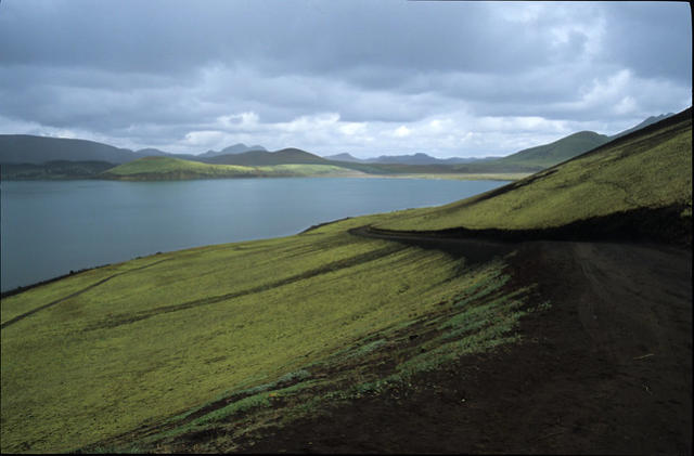
arrived at the surreal Frostathavatn Lake – a calm blue expanse surrounded by
black lava flows, streaked with bright green moss. It was a landscape
photographers dream, and I could quite easily have spent a couple of hours
exploring with a camera and tripod. As it was, the bus stopped for just a few
minutes, giving me time to grab a few shots before I had to put my camera
away to protect it from heavy rain. The lake is just north of Landmannalaugar
(probably three hours away on foot), so I knew that we were getting close to
the trailhead.
Lake Frostastathavatn.
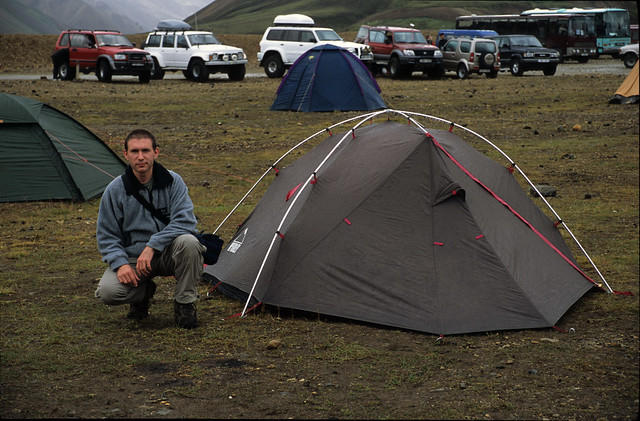
I knew that Landmannalaugar would be busy, because August is the peak season
for doing the trek, but I was a little unprepared for the sight that greeted me
when we arrived. The road to the camp was lined with enormous 4WD off-road
vehicles and tour buses. In front of the surprisingly large wooden hut itself, was
a wide campsite, dotted with many tents. It may have been crowded, but at
least there would be other people around on the trail in case I ran into any
major difficulty. It was raining as I got off the bus, but luckily not very cold. As
soon as I got my backpack out of the hold, I wasted not time in selecting a spot
on the campsite, cleared away the stones and rubble and pitched my tent. After
that, I got some sleep while a heavy rain shower passed over.
Me and my tent at Landmannalaugar.
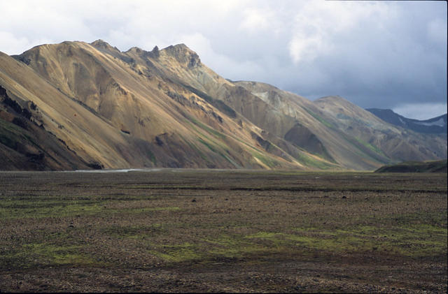
I woke up a couple of hours later, feeling refreshed. When I emerged from the
tent, I found that although it was still cloudy, it was much lighter. The cloud
base was also higher, and now I could see some of the beautiful beige rhyolite
mountains that lay across the river. I took some photos, and then went to check
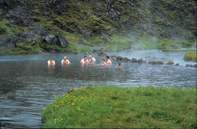
out Landmannalaugar’s other attraction – the geothermal pool. This lies at the
foot of the jagged wall of black volcanic rock, which was formed by a huge lava
flow. The pool is located where two streams flow out from the lava field and
into a marshy, grassy area. One stream is extremely hot due to natural
geothermal action and the other is a normal Icelandic stream (i.e. extremely
cold). The two mix to form a pool that is the perfect temperature for bathing,
and with a comfortable gravel bed. As a result, people come from miles around
to enjoy a soak in the waters whilst admiring the amazing scenery all around.
The pool is reached via a long walkway of duckboards, placed over the marsh to
protect them from damage. The marsh was a strange sight, dotted with tiny
yellow flowers and white tufts of cotton grass, but with steam and black jagged
rocks rising behind. After I had taken a few photos, I knew that I couldn’t pass
up the opportunity to take a dip. I went back to the tent, changed into my
swimming shorts and padlocked my clothes and camera inside. I hoped that
nothing would get stolen while I was away. Unfortunately, I realized that one
thing I had forgotten to bring from the UK was a lightweight trekking towel to
dry myself with! The pool turned out to be fantastic, just the right temperature
and very relaxing. It was strange that there were places where there were very
hot or cold currents and occasionally a blast of heat seemed to come direct
from the gravel at the bottom of the pool.
Rhyolite mountains at Landmannalaugar.
The geothermal pool at Landmannalaugar.
After my dip and cold walk back to the tent (through the rain, with only my
swimming shorts on), I got changed and went over to the hut itself. I paid my
camping fee to the wardens, and also signed the emergency book and gave the
date of my intended departure on the walk to Skogar. The book was designed to
be of use to rescuers if I failed to show up at Skogar (I had given my parents
instructions to raise the alarm if I hadn’t called them on the day I was due to
arrive there).
By then it was early evening and I was still tired from lack of sleep, so I cooked
my evening meal on my MSR stove (which I was relieved to see had survived the
journey and was working well) and turned in for the night. I wanted to get a
good night’s rest because the first day of the trek the next day was also the
longest, and my pack would be at it’s heaviest. An early start would be essential
if I was to cover the 20km to the next camp at Hvangil.
Day Two – 9th August 2002.
I had set my alarm for first light, and was soon up and out of the tent. I set
about what would become the routine – I cooked my breakfast on the stove,
packed away all my equipment and readied the backpack for the off. When I
was ready to go I felt relieved that I had got to the start of the trek on time and
without any problems, now it was just down to me to make the distance each
day and stay on schedule. With considerable effort, I hauled my pack onto my
back and was amazed at how heavy it felt now that it was fully loaded with fuel
and water. It must have weighed at least 56 pounds.
I set off to the side of the hut near the marsh, where the trail started. There
was a big sign there indicating that this was the Landmannalaugar to Thorsmork
trek (I was going on past Thorsmork to Skogar) and showed an engraved map of
the route. The trail led straight up a defile in the lava flow, and soon I was
looking down on the hut and campsite, with all the different coloured tents
dotted around. My early start meant that there were no other walkers that I
could see, and it was eerily silent as I walked across the barren expanse of the
lava field. I had tested my GPS receiver at Landmannalaugar and found that the
waypoints that I had entered in the UK were accurate, so I was able to track my
progress along the trail very easily.
The view back down to Landmannalaugar.
Further along the lava field, I came to a point that overlooked a wide flat
expanse of marsh, surrounded by rhyolitic mountains. A swift flowing, white
river, ran down from the mountains and snaked across the dell. From there, the
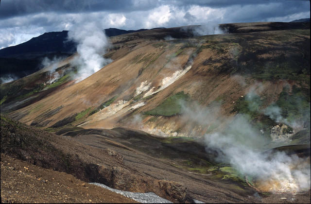
path was flanked by the mountains, and I came across the first geothermal
vents of the trek. In one place the whole mountainside was dotted with plumes
of gas and steam. In others, the vents were mere wisps that emerged from the
tiniest holes in the ground. There was a heavy smell of sulphur in the air. This
was the first time I had ever been to a volcanically active area, and it was
fascinating to see.
Among the rhyolite mountains near Landmannalaugar.
The path began to climb, leading over undulating ridges that gave a fine view
back to the lava flow and Landmannalaugar. In the hollows between the ridges
there were often snow fields that were left over from winter and slowly
melting. Soon I was in the middle of the geothermal field called Storihver. I was
lucky in that the sun had come out between the clouds, casting a beautiful
warm light on the multi-coloured mineral streaks of the rhyolite hills all around.
In the little valleys between the hill crests, there were many spectacular
geothermal vents with heavy deposits of crystalised sulphur around the fissures
in the ground. In one hollow, right next to the path was a large hole that was
ejecting scalding hot water. The accompanying noise that it made was
incredible, a low frequency throbbing that sounded like someone banging a
drum under my feet. I could feel the vibrations through the earth.
Sunlight on the mountains.
It took me a long time to pass through the geothermal area, because each hill
crest or bend in the track revealed either a spectacular view or a dramatic vent
and I was continually stopping to take photographs. I had found that my pack
was so heavy that my muscles were shaking too much to take photos with it on.
So every stop meant I had to take the pack off and give myself a minute or two
to rest. I was already concerned about whether I would manage to cover the
whole of the distance to the Hvangil camp that day.
Geothermal activity at Storihver.
After Storihver, the track climbed steeply up a black lava and ash slope. All
around were chunks of dark and glassy obsidian rock that is released during
volcanic eruptions. Crossing a snow field, I passed a family coming in the
opposite direction – only the second group of people I had seen that day. When I
reached the pass that I was heading for, I looked down to see the red, white and
blue of the Icelandic flag flying above the Hrafntinnusker hut. My guidebook
notes told me that some people camp here, but many think it is too bleak and
head on to the next hut at Alftavatn. I had to agree with them, it was high, cold
and rugged terrain up there and did not look at all inviting. It was the kind of
place that would be fine one minute, and subjected to a severe blizzard the
next. In any case, I had never planned to stop there and so I pushed on past the
hut and down the hill.
View of the Hrafntinnusker Hut.
I found myself starting out on what was to be the most demanding section of
walking that day. The path travelled on a roller coaster route up and down
steep sided ravines. At the bottom of each was usually a mushy snow field that I
had to trudge across, before struggling up the other side. Care was needed on
the way down each of these, because the black ash underfoot was treacherous
and it was easy to loose my footing. The worst of these ravines proved to be
quite unnerving. I had made my way down the ash slope and as I reached the
bottom, I realized that the snow field there had started to melt from the
inside, and had begun to break through at the surface. This had left two gaping
ice caves exactly either side of the point where the path left the ash and
crossed the snow. I could see down into these ice hollows and could make out
running water some fifteen feet down. It was clear to me that as I left the ash,
I would have to make sure I didn’t slip, because this would mean a very nasty
fall down under the snow and into the water. If I didn’t slip, then I would be
standing un-roped on a fragile snow bridge that might collapse under my
weight. The only reassuring thing was that I could see fresh dusty black
footprints in the snow, so I knew that someone had crossed safely very recently.
Luckily, I kept my footing, the snow held and I was able to get to the other side
without incident. Another ravine was memorable for a different reason, a
stream at the bottom emerged from a perfectly formed tunnel under the ice,
but the stream had deposited strange bright orange mineral deposits onto the
black ash. The contrasting colours of orange, white and black looked like they
belonged to an alien landscape.
This part of the route seemed to be endlessly creased, like the waves on the
sea, and as I neared the end of it, I was absolutely shattered. My legs were
strong and not a problem, but the weight of my pack and lack of strength in my
upper body had meant that one of the shoulder straps was digging in and I was
in a fair amount of pain. I kept going by telling myself that this day would easily
be the hardest of the whole trek, because the pack was at its heaviest with all
the food and fuel, this leg was the longest and it was over extremely difficult
volcanic terrain. If I could push on to the end, things should only improve from
there. Even though I tried to hold this thought, my morale took a big knock
when I climbed out of the final ravine to see that the path climbed up a
horrendously steep slope and up onto the Jokultungur Ridge. As I trudged up the
path, my feet were sliding in thick, orange mud that was streaked with the
most amazing colours. I assumed that the different hues came from various
nasty chemicals that had been produced during volcanic activity. The overall
effect was very much like a mixture of oil paints on an artist’s palette. At the
crest of the ridge, my efforts were rewarded with an incredible view out over
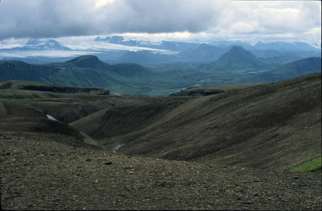
the route ahead. Sharp, pyramidal mountains reared up out of a black and
inhospitable lava desert, and stretching across the horizon was the huge
Myrdalsjokull ice cap. I could also see Alftavatn (Swan Lake), shimmering in the
middle distance.
The view towards Alftavatn.
As I descended from the ridge, the path led down a series of switchbacks,
passing several fumeroles. These were spewing out large plumes of gas, that
stank of hydrogen sulphide. Once clear of these, the trail dropped very steeply
down a sharp hill, and levelled out next to a river. By now, my shoulder was
worse than ever and each step brought a jolt of pain. Worried that if I pushed
myself too hard I might not be able to walk at all the next day, I decided to
take a long break. I set down my pack, got out my stove and made myself a
mug of hot chocolate. I took the opportunity to take a couple of painkillers with
the drink, and also spent some time taking some photographs using my mini
tripod.
I was briefly confused as to exactly where to go next, because the wooden
marker posts were laid out in such a way that it appeared that the trail went in
two different directions. I followed the river in the direction I thought I should
be heading, and came upon a few people who were getting ready to wade
across. The water was absolutely freezing, but crossing rivers like this was a
regular feature of the walk.
From there, the trail merged with a 4WD track which went all the way to the
hut at Alftavatn. I looked at my GPS and could see that my intended camp site
at Hvangil was still several kilometers away, so I decided it would be best for
me to camp at Alftavatn and make up the distance the next day. Next to the hut
was a small grassy camping area with a picnic table, and I set up my tent next
to the few others that were there. It was a pretty bleak spot on the whole. The
lake is at the bottom of a wide bowl valley, surrounded by low craggy
mountains. The exposed position meant that it was quite windy, and I knew it
was going to be a cold night. Before the sun set completely, I took a walk across
the grass and moss to the shore of the lake. It was eerily still, and the cold dark
water lapped quietly against the black lava sand beach.
As I ate my meal at the picnic table that evening, I was joined by a group of
Icelanders who had arrived in an enormous 4WD vehicle. They were chatting
away in Icelandic, when one of them cracked a joke in English. When I smiled,
the ice was broken and they started talking to me about the trek and where I
was heading. They all spoke very good English and were a really friendly bunch.
I discovered that we were heading in the same direction and would be at the
same site the next evening – at the Botnar hut. However, they were ending their
trip at Thorsmork rather than Skogar.


Day Three – 10th August 2002.
With distance still to make up from the day before, another early start was in
order. The track skirted the lake on the left hand side, crossed another shallow
but fast flowing river, and then climbed up and along a series of grassy hillocks.
As I was leaving Alftavatn, a bus was on its way out as well, and for about
twenty minutes or so, it seemed that everywhere I looked I could see it
struggling up yet another hill or ridge in front of me. It must have been a very
long and winding track back to civilization.
It wasn’t long before I was looking down from the top of a green and grassy
slope onto the Hvangil hut and the start of the black lava desert. My guidebook
described Hvangil as a pleasant oasis, but it didn’t look too inviting to me,
especially when viewed through a mist of chilly drizzle. I hurried on past the
hut, glad that I had decided to camp at Alftavatn the night before. I picked up
the marker posts once more, and these led me out of Hvangil, through a rubble
field of shiny, glassy lumps of obsidian. The black lava desert stretched as far as
the eye could see, overlooked by the green grey mountains and an overcast sky.
The track soon rejoined the 4WD road, the chunks of obsidian disappeared and I
found myself trudging in silence across the expanse of black ash. Bleak as it was
here, it was still capable of supporting life, and dotted around were small
alpine plants with little white flowers.
Crossing the black lava desert, Iceland.
I came to the first big river of the trek, the Kaldaklofskvisl, which was a raging
torrent and grey with sediment. This was one of the few rivers on the walk to
have a proper wooden footbridge – there was no way it could be forded on foot.
Just a bit further on down the track and it was time for me to go wading once
more – this time through the knee deep, extremely cold waters of the
Blafjallakvisl River. As I reached it, a bus full of tourists was crossing. The
occupants offered to ferry me across in the bus, but I felt that that would be
cheating and politely declined. After I had gone through the hassle of zipping off
my trouser legs, putting on my river sandals and loosening the straps on my
rucksack, I shuffled sideways into the water. I faced upstream as I crossed,
leaning forward slightly on my trekking pole, which was upstream and directly
in front of me. The water was extremely cold; at first I felt it, then my legs
went numb, and finally about two thirds of the way across they felt as though
they were on fire with pain. When I got to the other side it took a few minutes
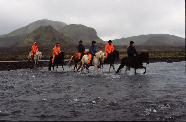
for normal feeling to return. As I stood on the bank recovering, a large group of
riders appeared on horseback, followed by a further group of rider-less horses. I
managed to grab my camera and take some photographs of them splashing
through the river.
The Blafjallakvisl River, Iceland.
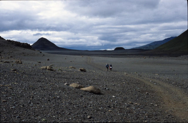
From there, I had a lonely plod across the lava desert. Occasionally I set down
my pack at the side of the 4WD track to sit on it and rest, or to take
photographs. When I was resting the silence was most noticeable; only the
breeze could be heard. Sometimes I could see other trekkers on the horizon,
but apart from that I was alone. The scenery here was dramatic, in the distance
I could see the Myrdalsjokull ice cap, and closer to the path were the steep
sided triangular mountains. After five kilometers, I came to the banks of the
Innri-Emstrua river. This was the second major river, and was crossed by means
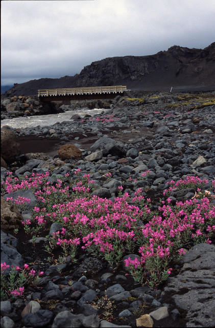
of a large and sturdy wooden bridge. Before I crossed, I noticed some beautiful
pink flowering plants growing amongst the rocks on the bank. I took some
photographs of these with the bridge in the background. When I returned to the
UK, I looked these up in one of my father’s books on the wild flowers of Europe.
I found that the plants I had seen were called ‘River Beauty’ and of all the
places in northern Europe, they only grow in Iceland.
'River Beauty' Growing On The Banks of the Innri-Emstrua River.
It seemed that after the bridge, the ash subsided and was replaced with a stone
and gravel plain. Here, the path forked and a signpost pointed to the left hand
branch as the one to take to reach the Botnar hut. By this point I was quite
tired and my shoulder was hurting again, so I sat at the side of the track and ate
my lunch. My lunch was similar every day of the walk and tended to consist of a
one-sixth portion of my pack of cheese, a stodgy flapjack, a fruisli bar and half
a packet of Brazil nuts. This food was packed with energy and didn’t need any
preparation or cooking on the stove.
After my rest, I began the walk to the Botnar hut and headed out across the
plain. At first it passed through a wide field of large rocks and boulders and
then narrowed into a windblown valley that was overlooked by small stony hills.
Once again it proved difficult to know which path to take as there were many
that interlinked, but they all proved to lead in roughly the same direction.
On the way to the Botnar hut.
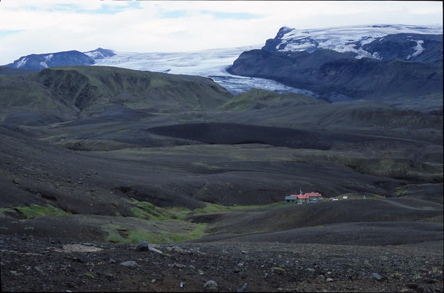
As I neared Botnar Hut, I ascended and descended a series of black hills covered
in thick lava ash, with impressive views of the ice cap. It started to rain and I
noticed the strange way that the ash immediately and silently soaked up the
droplets as they landed.
At last, the trail led down a final slope to the hut itself. The sun broke through
the clouds as I arrived, and it was even warm enough to take off my fleece
jacket. As soon as I looked for somewhere to pitch my tent I realized it was
going to be an uncomfortable night. The only flat area near the hut was covered
in grass tussocks and proved extremely uneven. I chose the most reasonable
spot I could find and set up camp. As usual, the facilities were surprisingly good.
The hut itself was occupied, but there was a small toilet / wash block with
running water, toilet paper and even hand soap!
Approaching Botnar hut.
That evening, I had just finished eating my meal and was sitting at the nearby
picnic table, when I was joined by the Icelanders I had spoken to at Alftavatn.
We resumed our conversation about the trek and using a map, they showed me
the route of a side trip they had done that day. It had taken them off the main
route and up a valley to a tongue of the ice cap. As we talked they offered me a
drink. I declined at first, as I didn’t want to impose, but they persisted and in
the end I was pleased to accept the massive slug of scotch whiskey that they
poured into my trek mug! After we were all well and truly under the influence,
it was decided that an evening walk would be good, and we set off to see the
nearby Markarfljotsgljufur canyon. My travel guide had enthused that “this
gaping green canyon will take your breath away”. We made our way up a steep
ash slope that was dotted with clumps of bright green moss, until we found
ourselves standing on a rocky outcrop overlooking a massive gash in the earth.
Although it was fairly late in the evening by this point, it didn’t get really dark
until midnight, so there was still plenty of light to see by. We could hear the
roar of the river below, and as we stared out over the sheer drop, sea gulls
wheeled between the walls of rock. Here and there, the sides of the canyon
were streaked with red – evidence of iron deposits.
As the light finally began to fade, we made our way back down into the camp,
and turned in for the night.
Day Four – 11th August 2002.
My alarm woke me early as usual, and I soon realized I had a terrible hangover. I
was feeling distinctly queasy after all that whiskey. However, I was very glad
that I had drifted off to a drunken slumber because when I awoke, I found that
my camping place was so uncomfortable that I would never have got a minute’s
sleep all night otherwise! It was so bad that once awake, I couldn’t stand lying
there for more than a few minutes with the lumpy tussocks digging into my back
and I was up and out of the tent in no time.
Armed with my camera, I retraced the walk up to the canyon and took some
photographs. When I returned, my head had cleared a bit and I was ready to
cook my breakfast. I said goodbye to the Icelanders who were also heading to
Thormsmork, but would be staying at a different hut.
The day’s walk started with the track taking a dogleg and dropping down to
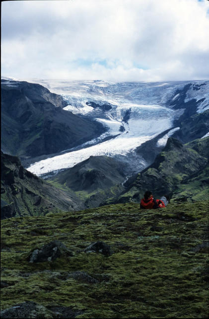
cross the Fremri-Emstrua River. This part of the walk commanded a great view
of the Entujokull glacier tongue sweeping down the valley. The section
immediately before the river was so steep that there was a permanent knotted
rope to safeguard the descent, and I found this extremely awkward with such a
heavy pack. The Fremri-Emstrua was crossed on a well-made wood and scaffold
bridge.
The afternoon’s walk was the least inspiring part of the trek for me. The first
part wasn’t so bad – because there were at least occasional views of
Markarfljotsgljufur. Then the path took me through a strange landscape of
gullies surrounded by green mountains. I ate my lunch at the bottom of one
deep gully, before trudging across a plain that was interspersed with awkward
escarpments of rock. It rained heavily from time to time, including at one of my
rest stops where I was too tired to do anything but sit on my pack and watch the
water run off my jacket.
Eventually, the weather cheered up a bit and I reached a small footbridge
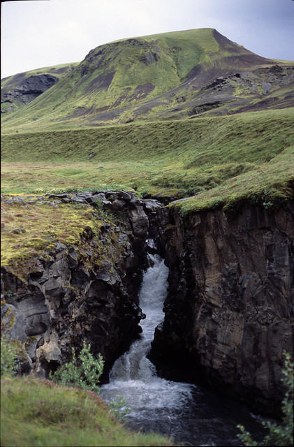
where the river Ljosa spurts through a narrow little gorge. From there, the
track climbed up a steep but pleasantly grassy hill. On the other side, it fell
steeply down a gravelly path to the river crossing that I had been worried about
the most – the Thronga. My travel guide had advised that anyone crossing alone
should be especially cautious. As I waded into the bitterly cold water I was
relieved to find that it was only knee deep at worst. It was certainly fast
flowing, but relatively shallow (I later learnt that this was because 2002 had
been an extraordinarily dry year in Iceland).
The Ljosa River.
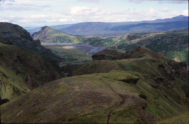
On the other side of the Thronga the path entered the Thorsmork woodlands
and the trekking scenery changed dramatically once again. The desolate lava
fields and barren hills were replaced with a fairy-tale woodland of stunted sliver
birches, mushrooms and flowers. I followed the track for a very long way,
wondering if I had taken a wrong turn, before eventually there were signs for
the Thorsmork hut ahead. The track broke free of the woods, and descended
into the wide Thorsmork valley. Suddenly, in front of me was the Thorsmork hut
itself, set in a beautiful grassy valley. When I arrived, the sun was shining and a
chilly but drying breeze was blowing. I put up my tent next to one of the picnic
tables and opened it up to allow the wind to dry out the inside.
Having paid my camping fee at the hut, I made my way down to the wash block
and took a hot shower. It was expensive, but it made me feel a lot better. By
then, the evening light was starting to fade, and the last rays of the sun were
illuminating Eyafjallajokul. Having taken some photographs, I cooked my
evening meal on the stove and went to bed.
Day Five – 12th August 2002.
As I was cooking breakfast, I struck up a conversation with two German guys
who were camping at the next plot. They told me that they had discovered that
it was possible to wade across the Krossa River that lay between the hut and
the trail up to the Fimmvorthuhals Pass. Initially I was sceptical about their
advice. The travel guides and trek descriptions I had read had warned that on
no account should the huge Krossa river be forded on foot, because there was a
great risk of drowning. However, they assured me that they had looked at the
river and found that a thin footbridge had been built across the deepest
channel (near the hut) where a 4WD is needed to cross and that the remaining
channels were no more than shin deep. I decided to at least have a look when I
set off, because it would shave several kilometers off that day’s trekking route.
This is because getting to the nearest footbridge across the whole river requires
a lengthy detour downstream and then a trek back up the opposite bank to
Gothaland, where the trail up to the pass begins. Sure enough, when I got down
to the river, I found that the first, main channel was bridged and when I tested
the depth of the remaining channels with my trekking pole, I saw that they
could all be crossed easily. It was just as they had described. Thanks to their
advice, I was soon drying off on the other side of the river and looking up at the
green peaks of Gothaland.
The Eyafjallajokul ice cap from Thorsmork.
I followed the wide 4WD track along the river to just east of the Basar hut,
where an obscure trail branched off for the Pass. It was difficult to find, even
though I had entered its start point as a GPS waypoint. The climb was very
steep, and at first was along a narrow track through stunted trees. As I climbed
higher up the side of the gorge, I found that in places the trail was quite
exposed. Eventually, I came to the first chain handrail, which had been put in
place to guard an awkward climb up and around a rock. As I hauled myself up,
there was a very frightening drop off behind me.
At the end of the chain, I found I had emerged from the gorge and was on a
long grassy ridge. This was easy walking at first, but then I discovered that it
became more rocky and narrowed to a thin path with very big drop offs on both
sides. The deep gorge I had just climbed out of was to my right, and another
equally deep one to the left. What made it worse was that in the middle of this
natural constriction, was an awkward rock. I really did not want to try my luck
at balancing on a rock with a 56lb pack on and certain death on either side, so I
found an awkward but safer solution. I made three trips across, first with my
camera and trekking pole to work out the best hand and footholds, then with
my tent (detached from my backpack) and finally with the pack itself. At one
point I was sitting astride the ridge with one leg dangling over one canyon and
the other leg hanging over the other drop off! I repeated this technique to cross
two more exposed sections a little further on. The Adventure Travel magazine
article that I read had warned that there were several very exposed points on
this leg of the trek.
Looking back towards Thorsmork, from Gothaland.
After coming to the end of the long ridge, I found that the trail climbed
extremely steeply up the side of the mountain, emerging on the Mornisheithi
plateau. Part of the plateau formed a promontory that looked back over almost
the whole route I had trekked up to now. The weather was clear and in the far
distance I could see the rhyolite mountains near Landmannalaugar. To my right
hand site was a very deep canyon, which was overlooked by a tongue of the
Myrdalsjokull ice cap. Myrdalsjokull is most notable for an enormous dormant
volcano, called Katla that lies beneath it’s surface. Katla is one of Iceland’s
most dangerous volcanoes. It has erupted sixteen times since the settlement of
Iceland and it has been calculated that each time it does so, the melting ice
generates a flow of water five times that of the Amazon River. The Icelander’s
have a special word for a volcanic eruption beneath the ice that causes terrible
flooding; such an event is known as a jokulhlaup, and is one of the island’s most
feared natural events.
View from Mornisheithi plateau to the Myrdalsjokull ice cap.
Retracing my steps back along the outcrop, I set off across the stony plateau.
The sun was now out and surprisingly strong. It wasn’t long before my nose and
forehead were slightly sun-burnt, which I hadn’t expected in Iceland. At the
end of the plain, I came to the most unnerving part of the trek by far, the
Heljarkambur ridge. The path dropped down from Mornisheithi and onto a ridge
between two gaping canyons. This ridge was actually quite wide and would not
have been any problem if it weren’t for a rock pillar at its far end. The path
was forced to edge round the pillar on the right hand side and above a very
nasty drop. Although the face was not sheer, it was so steep that any fall would
have resulted almost certainly in death or very serious injury. A chain handrail
had been set up to guard the route, but it looked wobbly and untrustworthy.
There were a couple of trekkers ahead of me, on the difficult section, so I
stopped on the ridge to give them time, catch my breath and perhaps see the
best way to tackle it. As I watched, I could not believe what I saw. One of them
suddenly departed from the path and tried climbing up the crumbly side of the
pillar. One slip and he would be gone. I was sure that I was about to witness a
death and I stood there in horror, hoping he would have the sense to get back
on the path. Fortunately, he realized that there was no other way and climbed
back down. The two then disappeared round the pillar and I could see they
were hauling themselves up a chain and onto the top of the outcrop. Then it
was my turn. When I reached the path, my first thought was that it looked like
suicide. In places it was only wide enough to accommodate one foot safely and
the exposure was horrendous. I immediately realized that I didn’t want to do
this three times. I would carry everything over in one go. At first I tried using
the handrail, which was fine near the anchor points (rusting metal pickets that
had been driven into the rock face) but got a lot worse in the middle of each
section where the chain was saggy and could swing dramatically. I gave up the
chain altogether when I grabbed hold of one picket and it swung round loosely
in the rock! I then tried steadying myself by leaning into the rock face and
feeling for handholds, but the face was made up of loose rock and crumbly lava
deposits that came away easily. I made it to the start of the steep section and
began hauling myself up the chain. As I dislodged a rock, I looked over my
shoulder, and saw it bounce just twice in a couple of hundred feet of descent!
Reaching the top, I collapsed on my pack, shaking with adrenalin and drenched
in sweat. However, I was also exhilarated because I knew that there were no
more exposed sections and the top of the pass was not very far away.
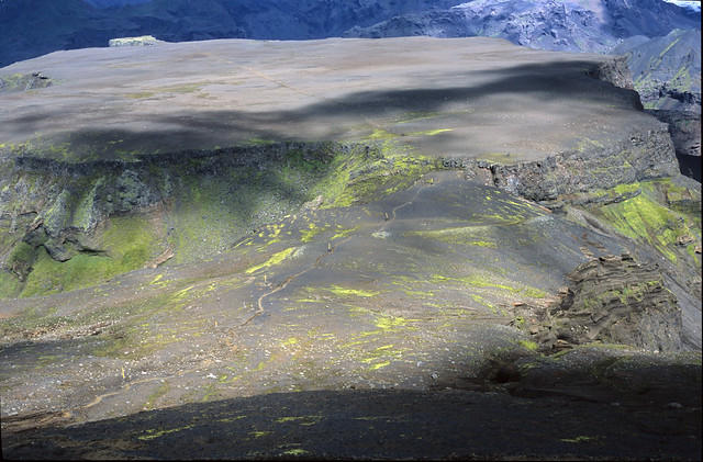
I was now on the part of the climb called Brattafonn and it looked like the
weather must have been very bad up there at times, because the way was
regularly marked with large bright yellow poles that were set close together. A
very tough and steep ascent led to the start of large black hills, left behind
where the ice cap had receded. By now, there had not been any sources of
fresh water for several miles. I had run out of water quite a while before and
was now tired and dehydrated. I was very relieved when I reached the lake that
lies just before the pass. Most of it was just a strange, dry, black lava bed but
against the ice on the far side was a deep blue pool. The ice cap had been
undercut by the pool and formed a shelf that jutted out. As the cap melted,
water was trickling from it and dropping down in curtains. Perching on the edge
of the water, I cupped my hands and drank as much water as I could. It was a
really eerie and beautiful spot.
View of the Mornistheithi plateau from Brattafonn.
The ice shelf and dry lake bed.
Pressing on across the weird and silent expanse of black ridges and slushy
snowfields, I eventually reached the crest of the Fimmvorthuhals pass and a T-
junction. To my right, the path led along the crest of the pass to the
Fimmvorthuhals hut. Directly ahead, it led down to the second hut (which is
actually just a shack used by skiers and off road drivers). I was very tired by this
point, so I turned right to investigate the hut and see if there was anywhere
decent to camp.
When I reached it, I found that it had been built perched on a fairly narrow part
of the ridge that was guaranteed to take a real battering if a storm came in off
the sea. I had read that the weather here is supposedly the worst in Iceland and
camping was not an inviting prospect. I went over to the hut and found that the
door was open. Inside were neatly made, comfy looking bunk beds and a
spacious loft. On the walls were grainy black and white photographs of
Icelanders with enormous ice axes posing in front of the hut in winter. If it
looked bleak now, I couldn’t imagine what it might be like up here at that time
of year. The hut was very inviting and comfortable and for a few minutes I
toyed with the idea of staying there. However, I soon decided against it. I
hadn’t booked the hut, and although it was unlikely that anyone was behind me
this late in the day, it would be typical to unload all of my equipment and settle
in, only for the party that had rightfully booked it to turn up and evict me.
Besides, if I stayed at the hut I would have failed my objective of doing my first
ever solo and unsupported trek. Before I left though, I wanted to get a drink of
water as I was extremely thirsty. The instructions in the hut said to turn on the
water supply by turning the yellow handle on the water valve outside through
ninety degrees. I found that it was rusted solid, and as I tried to turn it on the
handle came away in my hand – completely rusted and fatigued by exposure to
the harsh climate. There was still an alternative supply in a water tank for the
next visitors, but it didn’t look very appetising.
So, still thirsty, I made my way back to the T-junction and headed down to the
lower hut. The path continued down over slushy snowfields. Luckily some of
these had clear streams flowing over them, fed by the thawing ice. I was able
to refill my water bottle and re-hydrate myself. Other ice fields were more
menacing and contained deep holes in which the sound of rushing and gurgling
water could be heard. I felt quite uneasy about walking across these without
being roped to someone else, but none of the trek descriptions I had read had
mentioned any danger from these melting snowfields.